| Programme of EventsMembershipPublicationsEditorial BoardOfficers | Library | Medieval Graffiti Survey |
|
|
Hampshire Field Club & Archaeological Society |
| Registered Charity number 243773 | HomepageArchaeologyHistoric Buildings Hampshire Papers LandscapeLocal History |
St Nicholas, Bishop's SuttonPost code: SO24 0AD Grid Ref: SU 605320 CHR No: 641008
The church was built in the 12th century as a simple two bay structure of nave and chancel by the Bishop of Winchester, Henry de Blois. From this period date the fine south doorway with its characterful beakheads (Photo 2), and the wide chancel arch.
The church was later added to, and parts rebuilt. The chancel is of the early 13th century and has two surviving consecration crosses painted on each side of the east window. Pevsner refers to the early 14th century squint which may have served an anchorite’s cell or north chapel. At the west end are the four sturdy 14th century wooden posts supporting the bell turret. Some restoration was carried out in the Victorian period and a vestry added. The church contains some interesting monuments. In the chancel is a 15th century brass depicting a knight and lady and a ledger stone and monument to William Cowper, the anatomist and surgeon, who died in 1709. The Porch and South DoorwayUnsurprisingly, for a much-visited religious site, most of the graffiti is around the main entrance, the south doorway, the first point of contact for pilgrims, other visitors and local parishioners, where they could leave their marks and emblems of devotion. However, there are very few crosses, the symbols usually associated with pilgrimage, in this part of the church. Above the group of initials on the west side of the doorway (Photo 3), are radiating lines which are probably a scratch or mass dial. A stick inserted in a central hole at the top would have served as a gnomon, casting a shadow to show the hour of the day when particular religious offices would be carried out by the priest. These dials were usually next to the church entrance.
Most notable is the finely carved name and date R. Cranston 1752, engraved within the porch on the west side of the south doorway, on the impost over the column and continuing onto the door surround and jamb (Photo 4). I am indebted to my colleague, Helen Banham, for drawing my attention to the book Ropley’s Legacy by Chris Heal, which mentions Robert Cranston, labourer, of Bishop’s Sutton who, in 1744 undertook a perambulation around Bishop’s Sutton seeking to prove his right to two small areas of land.It would seem fair to assume that this is the same person, and that 1752 could be the date Cranston settled his claim.
The InteriorWithin the nave, there is graffiti on the east and west jambs of the north doorway. This includes sets of parallel lines, some of which could possibly be music staves, as one area has marks superimposed which could represent musical notation. On the north jamb of the chancel arch the graffiti includes several crosses, one of which has dots at the terminals and lines joined to form a triangle at the top (Photo 5).
On the east jamb of the south door is a mark made of 2 inverted intersecting Vs which could be the initial M ... or possibly a so-called Marian mark, incised as symbol of devotion to the Virgin Mary (Photo 6).
The ExteriorOn the angle between the nave and chancel on the south side three different types of marks can be seen, on blocks of stone one above the other (Photo 7).
At the top a group of dots have been drilled. The purpose of these is not known, although it is sometimes suggested that these are areas where stone has been scraped away to be used in folk remedies and potions, a tradition that is known to have occurred in holy places and shrines all over Christian Europe (James Wright, 2021). Below the dots is another scratch or mass dial, with lines radiating beneath a central hole. As these dials were usually next to the church entrance, this block has probably been moved and reused. Beneath this is an Ordnance Survey benchmark. Although not graffiti, this mark is of historical interest and can be seen marked on the Six-Inch Ordnance Survey map of 1872, as BM 276.5. Survey Archive154 photographs were taken during the survey. All images and record sheets are held by the Hampshire Field Club Medieval Graffiti Project archive and are available on request. A copy of this report has been lodged with the Hampshire Historic Environment Record and with the church, and the report has been posted on the HFC website. DisclaimerThis document has been prepared for the titled project or named part hereof and should not be relied upon or used for any other project or assessment without the permission of the Hampshire Medieval Graffiti Project. The full report is available as a PDF download. Surveyors: Mark Barden, Karen Parker, Aldous Rees, Karen Wardley. |
||
| Contact Any questions about the web site? Then email Webmaster |
||
 Photo 1: Exterior of St Nicholas'
 Photo 2: South doorway with 'beakheads'
 Photos 3: Mass dial with initials on the west side of the doorway.
 Photo 4: R Cranston inscription dated 1752.
 Photo 5: Crosses on the chancel arch.
 Photo 6: Initial M or a Marian mark.
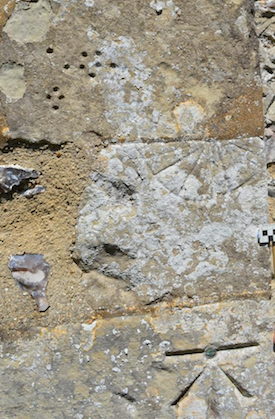 Photo 7: Drilled holes, a mass dial and an OS Bench Mark.