| Programme of EventsMembershipPublicationsEditorial BoardOfficers | Library |
|
|
Hampshire Field Club & Archaeological Society |
| Registered Charity number 243773 | HomepageArchaeologyHistoric Buildings LandscapeLocal History |
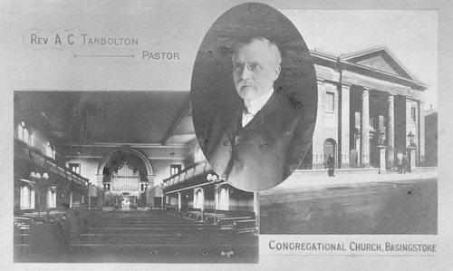
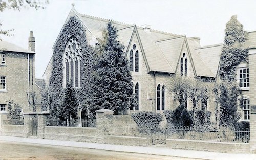
Landscape SectionReligious Buildings of Basingstoke - a virtual visitRoger Ottewill, Chairman of the Local History Section, who was due to lead, has provided most of the information for this virtual visit. The visit would have begun at the United Reformed Church, one of the most distinctive and iconic buildings in London Street, Basingstoke. This enlarged view, courtesy of the National Library of Scotland, from the 1873 25-inch OS map (this link will open in a new webpage; you may need to allow pop-ups) shows the church's location on London Street; it is marked 'Ind. Chapel' just above the 'L' of London. In 1900 celebrations were held to mark the 100th anniversary of these premises. Then known as London Street Congregational Church, Photos 1 & 2 below, it dated its origins to 1663. Details of the centenary can be found on the webpages of the Hampshire Archives Trust. The Buildings of England - HAMPSHIRE: Winchester and the North, p. 160 has a paragraph with some details of its development. An photograph on the Historic England Archive shows a clearer view of the front including the gates and railings.
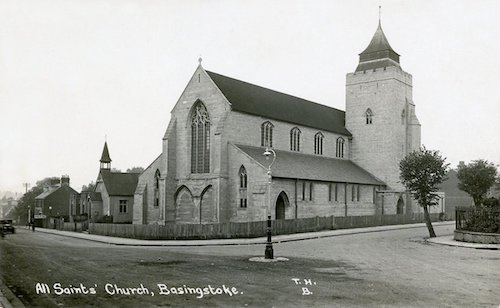
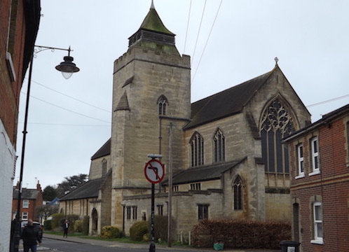
The second stop would have been at All Saints Church, see Photos 3 & 4. Built in the Gothic style the church was consecrated in September 1917. Until then the congregation had used an iron church which had been dedicated on All Saints Day 1902. This became the Church Hall when the new place of worship was opened. The pre-1917 church can be seen on the 1910 25-inch OS map while the present church building appears first on the 1932 25-inch OS map. The Buildings of England - HAMPSHIRE: Winchester and the North, p159, devotes most of the page to the church's history. Bob Clarke has researched and written an online article for the Victoria County History on the early years of All Saints Church.
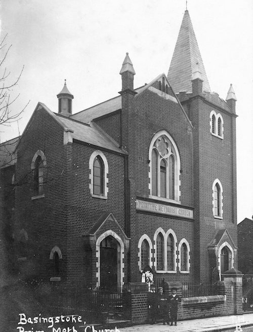
Visits would then have been made to the sites of three historic churches which were demolished as part of the town centre redevelopment: The Primitive Methodist ChurchSited on Sarum Hill, this church opened in 1902 and was demolished in 1970. The 1910 25-inch OS map shows the location on the west side of Sarum Hill. Photos 5 & 6 show the exterior and interior of the church respectively. Roger Ottewill has researched and written a Victoria County History online article about Primitive Methodism in the town.
Wesleyan Methodist ChurchThe original church was officially opened in 1876, Photo 6. This was replaced by the church building shown in the YouTube video (link below) in 1905. The old church was re-erected in Cliddesden. The 1896 25-inch OS map shows the original church, marked as a Chapel, opposite St. Michael's Church and Graveyard; the 1910 25-inch OS map shows the second church. David Webb has produced a number of YouTube videos on changes in Basingstoke, including one which shows images of the church before and during its demolition. Wesleyan Methodism celebrated its Golden Jubilee in 1920.
Immanuel (Countess of Huntingdon’s Connexion) ChurchThe 1873 25-inch OS map shows the church in Wote Street; it is the building to the left of the name: Lady Huntingsdon's Chapel. The church can be found on all of the later editions, up to 1940, of the 25-inch map for Basingstoke. The 1932 edition shows it sited across from a Bapt. Church on the map; further north, the Friends' Meeting House is marked. The following photo 7, courtesy of Alastair Blair, shows the church set back from Wote Street. Sadly, like the Wesleyan Methodist Church, it did not survive the 1960s redevelopment of Basingstoke town centre. The site of the church can be found just where the east side of Wote Street is set back behind the statue of the 'Church Stone'. The Basingstoke Gazette published a recent story on the statue, 18/06/2020, which gives its more popular local name.
Photo 8 - Image courtesy of Alastair Blair.
|
||||||||||||||||||||||
| Contact Any questions about the Landscape Section? Then email Mike Broderick Landscape Section Chairman |
||||||||||||||||||||||